
Learn More: Redlining and Urban Renewal
From the 1930s through the 1970s, real estate practices and federal government policies changed the landscape of Camden and other American cities. The campus of Rutgers—Camden is one result among many of this period of American urban history.
Redlining generally refers to discriminatory lending practices, especially discrimination based on race. The term comes from maps created by mortgage lenders and regulators during the 1930s that graded neighborhoods based on their residents and housing stock. On the maps, neighborhoods with the lowest rating—“hazardous”—appeared in red.
Maps by the federal Home Owners’ Loan Corporation (HOLC), an agency created in 1935, reflected local lending practices and established a system of rankings for the future. The HOLC map for Camden redlined most of North Camden, north of Cooper Street and east of Tenth Street, because of perceived negative characteristics of the neighborhood’s people and buildings.
In 1937, HOLC surveyors noted, “Due to erection of Delaware Bridge [the Benjamin Franklin Bridge], entire district has, and continues to, rapidly decline.” The survey reported:
- Despite a favorable location near industrial employers, the area had “many buildings being torn down by vandals and others by owners to save taxes.”
- The houses, many of them fifty years old or more, were in poor repair.
- The laborers who lived in the area included “questionable residents” whom surveyors perceived to be a mix of foreign-born white immigrants and Black residents, although in fact the neighborhood also included native-born, white homeowners.
- The survey also found a “great many” families receiving financial relief.
These factors led to a prediction that the area would continue to decline over the next ten to fifteen years. It was a self-fulfilling prophecy. Because of the redlining, mortgage lenders would be likely to limit their risks by avoiding areas deemed “hazardous.” The stigma created by the HOLC maps and others set the stage for further decay.
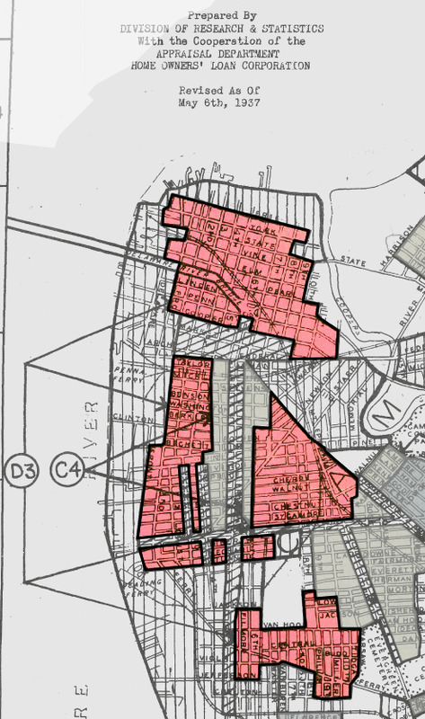
HOLC map showing "hazardous" areas of Camden, indicated in red. (Mapping Inequality)
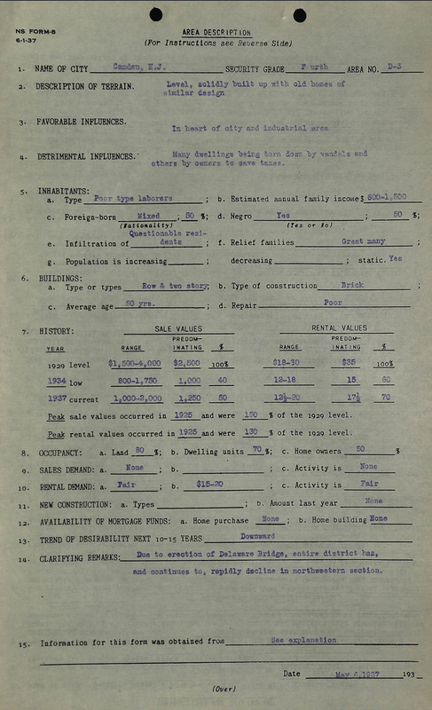
HOLC survey data for area including North Camden. (Mapping Inequality)
Urban Renewal
In the years following World War II, conditions in central cities suffered as many residents and businesses moved to a new generation of suburbs that catered to middle-class, nuclear families (but usually not Black families, who found that most suburban developers would not sell to them). People who once lived in Camden to be close to major employers like RCA or Campbell’s Soup could choose instead to live in a suburb like Cherry Hill and commute by automobile to Camden or Philadelphia.
The pattern of decentralized populations and decaying urban centers repeated in cities across the country, prompting federal action. Beginning with the federal Housing Act of 1949, the federal government provided funding for “slum clearance” to demolish “blighted” areas and make way for new, private residential development. The practice, which displaced lower-income people from their neighborhoods, became known as urban renewal.
By the mid-1950s, the federal program expanded to allow “slum” areas to be redeveloped for institutions like hospitals and universities. This created an opportunity for Rutgers University to expand its campus in Camden. The campus had been growing in the vicinity of Fifth and Penn Streets since 1946, beginning with the purchase of Ayer mansion (now the Admissions Office, 406 Penn Street). That purchase was made for two predecessor institutions, the South Jersey Law School and College of South Jersey, but by 1950 they had merged into Rutgers. With an eye toward expansion, the university began to buy more properties in the area.
In 1958, Rutgers proposed an urban renewal project to create a new, modern campus in Camden. City officials supported the initiative, although some residents of the area objected to their neighborhood being labeled as “blighted.” Demolitions occurred during the 1960s to create the Quad and surrounding buildings you see on the campus today.
--By Charlene Mires, posted September 27, 2026.

Aerial photograph of Camden, including the future campus area, c. 1926. (Library Company of Philadelphia)
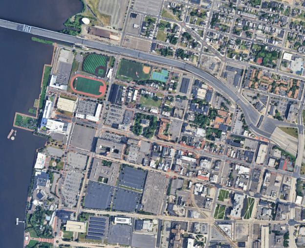
Similar aerial view, 2026. (Google Maps)
Sources
Camden newspapers (Newspapers.com).
Fishback, Price, and others. "New Evidence on Redlining by Federal Housing Programs in the 1930s." Federal Reserve Bank of Chicago Working Paper, January 3, 2022.
Gillette, Howard Jr. Camden After the Fall: Decline and Renewal in a Post-Industrial City. Philadelphia: University of Pennsylvania Press, 2005.
Hillier, Amy E. "Residential Security Maps and Neighborhood Appraisales: The Home Owners' Loan Corporation and the Case of Philadelphia." Social Sciene History vol. 29, no. 2 (Summer 2005): 207-33.
Jackson, Kenneth T. Crabgrass Frontier: The Suburbanization of the United States. New York: Oxford University Press, 1985.
Shumsky, Neal Larry, ed. Encyclopedia of Urban America. Santa Clara, Calif.: ABC-CLIO, 1998.
Teaford, Jon C. The Metropolitan Revolution: The Rise of Post-Urban America. New York: Columbia University Press, 2006.
Cite: Charlene Mires, "Redlining and Urban Renewal," Learning From Cooper Street, https://onlineexhibits.camden.rutgers.edu/s/cooper-street/page/redlining.